R in Marine Science: The Role of the R Statistical Computing Environment in Advancing Marine Science and Global Ocean Governance
This is a proposal for an "R in Marine Science" virtual conference. The objective is to showcase the R programming language in protecting our seas and oceans, and to build relationships with governments, global Organizations, NGOs and philantrophic organizations.
Abstract
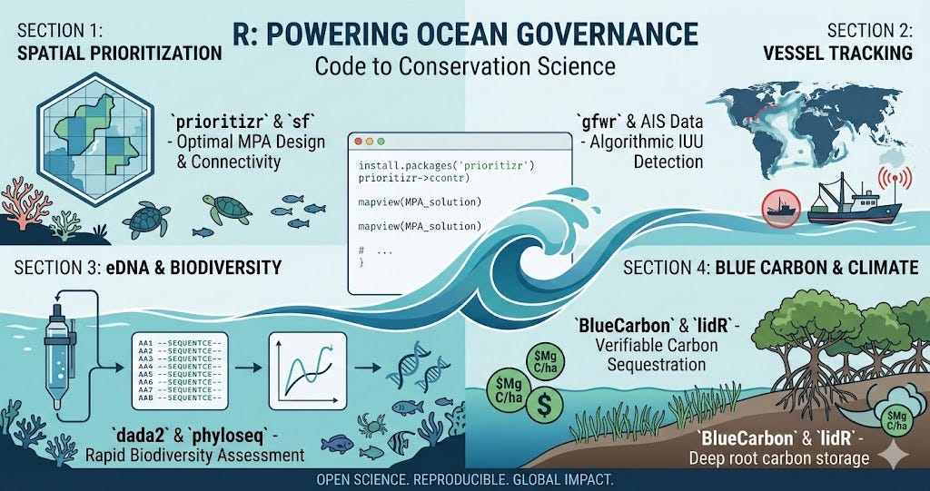
The management of marine ecosystems has transitioned from qualitative observation to a data-intensive discipline requiring rigorous, reproducible, and scalable analytical frameworks. As international mandates, such as the “30x30” initiative, necessitate the rapid expansion of Marine Protected Areas (MPAs), the R statistical programming language has emerged as the definitive open-source infrastructure for marine research. This article examines the technical applications of R in spatial conservation prioritization, vessel monitoring systems, and the quantification of blue carbon sequestration, highlighting its role in bridging the gap between raw oceanographic data and enforceable environmental policy.
I. Spatial Optimization and Systematic Conservation Planning
The designation of Marine Protected Areas (MPAs) requires the integration of heterogeneous datasets, including bathymetry, species distribution models, and socio-economic indicators. Systematic conservation planning (SCP) utilizes R to solve complex optimization problems that balance biodiversity representation with the displacement of human activities.
Central to this workflow is the prioritizr package, which employs integer linear programming (ILP) techniques. Unlike traditional heuristic approaches, R-based ILP solvers provide mathematically optimal solutions for reserve design. By incorporating spatial layers processed through the sf (simple features) and terra packages, researchers can model “connectivity” between disparate protected zones—ensuring that larval dispersal and migratory corridors are maintained across vast oceanic scales.
II. Algorithmic Monitoring of Maritime Activity
Enforcement remains the primary challenge in high-seas governance. The advent of the Automatic Identification System (AIS) has provided a wealth of geo-spatial data, yet the volume of this “big data” requires automated processing to detect illegal, unreported, and unregulated (IUU) fishing.
The R ecosystem provides a standardized interface for querying and analyzing these global vessel datasets. Packages such as gfwr (Global Fishing Watch in R) allow for the programmatic retrieval of vessel identities and loitering events. By applying hidden Markov models (HMMs) or machine learning classifiers within R, scientists can distinguish between transit behavior and active fishing maneuvers. This transformation of raw AIS signals into “effort layers” enables coastal states to implement dynamic ocean management, where protection levels can be adjusted based on real-time vessel density.
III. Genomic Frontiers: eDNA and Biodiversity Assessment
Traditional morphological surveys of marine biodiversity are often invasive and logistically constrained by depth and sea state. Environmental DNA (eDNA) metabarcoding has revolutionized biological monitoring by detecting genetic material shed by organisms into the water column.
The bioinformatics pipeline for marine eDNA is increasingly anchored in R. The dada2 and phyloseq packages enable the processing of high-throughput sequencing data, from raw FASTQ files to taxonomic assignment. These tools allow for the calculation of alpha and beta diversity metrics across entire ecosystems, providing a high-resolution “biopsy” of ocean health. This molecular approach is vital for assessing the efficacy of established MPAs, as it can detect the recovery of cryptic or rare species that traditional visual censuses might overlook.
IV. Quantifying Blue Carbon for Climate Mitigation
Coastal ecosystems, including mangroves, seagrasses, and salt marshes, function as hyper-efficient carbon sinks. The quantification of this “Blue Carbon” is essential for the development of verified carbon credits and the inclusion of coastal wetlands in Nationally Determined Contributions (NDCs) under the Paris Agreement.
R serves as the primary engine for the “Measurement, Reporting, and Verification” (MRV) protocols required by carbon markets.
- Sediment Analysis: The
BlueCarbonpackage facilitates the calculation of Soil Organic Carbon (SOC) stocks, correcting for core compaction and varying bulk densities. - Biomass Estimation: The
lidRpackage allows for the processing of Light Detection and Ranging (LiDAR) data to create 3D forest structures. By applying allometric equations in R, researchers can calculate above-ground biomass carbon with high precision. - Predictive Modelling: The integration of R with the InVEST (Integrated Valuation of Ecosystem Services and Tradeoffs) models allows for the simulation of avoided emissions, providing the “additionality” proof required for the issuance of carbon offsets.
V. Reproducibility and the Democratization of Science
Beyond specific analytical packages, the most significant contribution of R to marine science is the shift toward Open Science. Through the use of Quarto and R Markdown, the entire pipeline—from data ingestion to statistical inference—is contained within a single, executable document.
This transparency is fundamental to ocean governance. When a sovereign nation or an international body declares a fishing moratorium based on R-generated models, the underlying code acts as a “legal audit trail.” Furthermore, because R is open-source and computationally accessible, it empowers scientists in the Global South to lead their own conservation initiatives, ensuring that the tools for ocean protection are not gatekept by proprietary software costs.
Conclusion
As the global community moves toward the goal of protecting 30% of the ocean by 2030, the reliance on robust, scalable, and transparent data systems will only intensify. R has moved beyond its origins as a statistical language to become a comprehensive platform for maritime spatial awareness, biodiversity monitoring, and climate-risk modelling. By providing a unified environment for these diverse tasks, R ensures that the governance of the world’s oceans is rooted in the highest standards of scientific evidence.